Georgia County Map
Georgia has 159 counties, the second most of any state after Texas. Fulton County, which includes most of Atlanta, is the most populous with 1,066,710 residents in 2020; Ware County, around Waycross, is the largest by land area (899.2 sq mi). Atlanta, the capital, is the county seat of Fulton County.
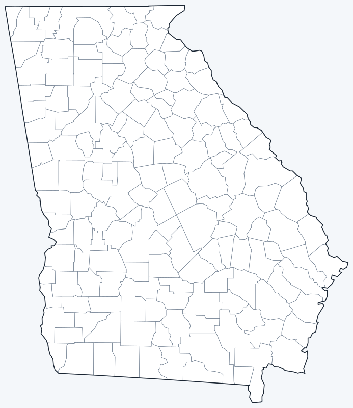
County lines are switched on when the interactive map loads. Hover over a county to see its name, or untick Show counties to hide them.
List of Georgia counties
Click a column heading to sort. Land area excludes water.
| County | County seat | Population (2020) | Land area (sq mi) |
|---|---|---|---|
| Appling County | Baxley | 18,444 | 508.3 |
| Atkinson County | Pearson | 8,286 | 342.7 |
| Bacon County | Alma | 11,140 | 284.1 |
| Baker County | Newton | 2,876 | 342.0 |
| Baldwin County | Milledgeville | 43,799 | 258.7 |
| Banks County | Homer | 18,035 | 232.6 |
| Barrow County | Winder | 83,505 | 161.0 |
| Bartow County | Cartersville | 108,901 | 458.9 |
| Ben Hill County | Fitzgerald | 17,194 | 250.1 |
| Berrien County | Nashville | 18,160 | 453.4 |
| Bibb County | Macon | 157,346 | 249.4 |
| Bleckley County | Cochran | 12,583 | 215.9 |
| Brantley County | Nahunta | 18,021 | 443.2 |
| Brooks County | Quitman | 16,301 | 493.2 |
| Bryan County | Pembroke | 44,738 | 437.6 |
| Bulloch County | Statesboro | 81,099 | 676.0 |
| Burke County | Waynesboro | 24,596 | 827.0 |
| Butts County | Jackson | 25,434 | 183.7 |
| Calhoun County | Morgan | 5,573 | 280.4 |
| Camden County | Woodbine | 54,768 | 630.4 |
| Candler County | Metter | 10,981 | 243.1 |
| Carroll County | Carrollton | 119,148 | 499.1 |
| Catoosa County | Ringgold | 67,872 | 162.2 |
| Charlton County | Folkston | 12,518 | 780.1 |
| Chatham County | Savannah | 295,291 | 433.1 |
| Chattahoochee County | Cusseta | 9,565 | 248.7 |
| Chattooga County | Summerville | 24,965 | 313.3 |
| Cherokee County | Canton | 266,620 | 421.1 |
| Clarke County | Athens | 128,671 | 119.2 |
| Clay County | Fort Gaines | 2,848 | 195.4 |
| Clayton County | Jonesboro | 297,595 | 141.7 |
| Clinch County | Homerville | 6,749 | 815.0 |
| Cobb County | Marietta | 766,149 | 339.8 |
| Coffee County | Douglas | 43,092 | 592.3 |
| Colquitt County | Moultrie | 45,898 | 547.0 |
| Columbia County | Appling | 156,010 | 290.2 |
| Cook County | Adel | 17,229 | 228.5 |
| Coweta County | Newnan | 146,158 | 441.1 |
| Crawford County | Knoxville | 12,130 | 324.9 |
| Crisp County | Cordele | 20,128 | 272.7 |
| Dade County | Trenton | 16,251 | 174.0 |
| Dawson County | Dawsonville | 26,798 | 210.8 |
| DeKalb County | Decatur | 764,382 | 267.7 |
| Decatur County | Bainbridge | 29,367 | 597.2 |
| Dodge County | Eastman | 19,925 | 496.0 |
| Dooly County | Vienna | 11,208 | 392.6 |
| Dougherty County | Albany | 85,790 | 328.6 |
| Douglas County | Douglasville | 144,237 | 200.1 |
| Early County | Blakely | 10,854 | 512.6 |
| Echols County | Statenville | 3,697 | 420.4 |
| Effingham County | Springfield | 64,769 | 478.8 |
| Elbert County | Elberton | 19,637 | 351.1 |
| Emanuel County | Swainsboro | 22,768 | 680.6 |
| Evans County | Claxton | 10,774 | 182.9 |
| Fannin County | Blue Ridge | 25,319 | 387.1 |
| Fayette County | Fayetteville | 119,194 | 194.6 |
| Floyd County | Rome | 98,584 | 509.8 |
| Forsyth County | Cumming | 251,283 | 224.6 |
| Franklin County | Carnesville | 23,424 | 261.3 |
| Fulton County | Atlanta | 1,066,710 | 526.7 |
| Gilmer County | Ellijay | 31,353 | 426.2 |
| Glascock County | Gibson | 2,884 | 143.7 |
| Glynn County | Brunswick | 84,499 | 419.6 |
| Gordon County | Calhoun | 57,544 | 356.4 |
| Grady County | Cairo | 26,236 | 454.5 |
| Greene County | Greensboro | 18,915 | 387.5 |
| Gwinnett County | Lawrenceville | 957,062 | 430.8 |
| Habersham County | Clarkesville | 46,031 | 276.9 |
| Hall County | Gainesville | 203,136 | 393.0 |
| Hancock County | Sparta | 8,735 | 471.1 |
| Haralson County | Buchanan | 29,919 | 282.2 |
| Harris County | Hamilton | 34,668 | 463.8 |
| Hart County | Hartwell | 25,828 | 232.4 |
| Heard County | Franklin | 11,412 | 296.0 |
| Henry County | McDonough | 240,712 | 318.7 |
| Houston County | Perry | 163,633 | 376.0 |
| Irwin County | Ocilla | 9,666 | 354.4 |
| Jackson County | Jefferson | 75,907 | 339.7 |
| Jasper County | Monticello | 14,588 | 368.4 |
| Jeff Davis County | Hazlehurst | 14,779 | 330.9 |
| Jefferson County | Louisville | 15,709 | 526.6 |
| Jenkins County | Millen | 8,674 | 347.3 |
| Johnson County | Wrightsville | 9,189 | 303.0 |
| Jones County | Gray | 28,347 | 393.9 |
| Lamar County | Barnesville | 18,500 | 183.5 |
| Lanier County | Lakeland | 9,877 | 196.5 |
| Laurens County | Dublin | 49,570 | 807.3 |
| Lee County | Leesburg | 33,163 | 355.9 |
| Liberty County | Hinesville | 65,256 | 516.5 |
| Lincoln County | Lincolnton | 7,690 | 210.4 |
| Long County | Ludowici | 16,168 | 400.4 |
| Lowndes County | Valdosta | 118,251 | 497.2 |
| Lumpkin County | Dahlonega | 33,488 | 282.9 |
| Macon County | Oglethorpe | 12,082 | 400.7 |
| Madison County | Danielsville | 30,120 | 282.3 |
| Marion County | Buena Vista | 7,498 | 365.7 |
| McDuffie County | Thomson | 21,632 | 257.4 |
| McIntosh County | Darien | 10,975 | 431.4 |
| Meriwether County | Greenville | 20,613 | 500.9 |
| Miller County | Colquitt | 6,000 | 282.4 |
| Mitchell County | Camilla | 21,755 | 512.2 |
| Monroe County | Forsyth | 27,957 | 396.1 |
| Montgomery County | Mount Vernon | 8,610 | 241.1 |
| Morgan County | Madison | 20,097 | 347.4 |
| Murray County | Chatsworth | 39,973 | 344.5 |
| Muscogee County | Columbus | 206,922 | 216.5 |
| Newton County | Covington | 112,483 | 273.8 |
| Oconee County | Watkinsville | 41,799 | 184.3 |
| Oglethorpe County | Lexington | 14,825 | 439.1 |
| Paulding County | Dallas | 168,661 | 312.4 |
| Peach County | Fort Valley | 27,981 | 150.3 |
| Pickens County | Jasper | 33,216 | 232.1 |
| Pierce County | Blackshear | 19,716 | 340.5 |
| Pike County | Zebulon | 18,889 | 216.1 |
| Polk County | Cedartown | 42,853 | 310.3 |
| Pulaski County | Hawkinsville | 9,855 | 249.3 |
| Putnam County | Eatonton | 22,047 | 344.7 |
| Quitman County | Georgetown | 2,235 | 151.2 |
| Rabun County | Clayton | 16,883 | 370.1 |
| Randolph County | Cuthbert | 6,425 | 428.2 |
| Richmond County | Augusta | 206,607 | 324.3 |
| Rockdale County | Conyers | 93,570 | 129.8 |
| Schley County | Ellaville | 4,547 | 166.9 |
| Screven County | Sylvania | 14,067 | 645.8 |
| Seminole County | Donalsonville | 9,147 | 237.5 |
| Spalding County | Griffin | 67,306 | 196.0 |
| Stephens County | Toccoa | 26,784 | 178.9 |
| Stewart County | Lumpkin | 5,314 | 458.7 |
| Sumter County | Americus | 29,616 | 482.9 |
| Talbot County | Talbotton | 5,733 | 391.4 |
| Taliaferro County | Crawfordville | 1,559 | 194.6 |
| Tattnall County | Reidsville | 22,842 | 480.8 |
| Taylor County | Butler | 7,816 | 376.7 |
| Telfair County | McRae-Helena | 12,477 | 437.3 |
| Terrell County | Dawson | 9,185 | 335.8 |
| Thomas County | Thomasville | 45,798 | 544.6 |
| Tift County | Tifton | 41,344 | 260.9 |
| Toombs County | Lyons | 27,030 | 364.0 |
| Towns County | Hiawassee | 12,493 | 166.5 |
| Treutlen County | Soperton | 6,406 | 199.4 |
| Troup County | LaGrange | 69,426 | 414.0 |
| Turner County | Ashburn | 9,006 | 285.4 |
| Twiggs County | Jeffersonville | 8,022 | 359.3 |
| Union County | Blairsville | 24,632 | 322.1 |
| Upson County | Thomaston | 27,700 | 323.5 |
| Walker County | LaFayette | 67,654 | 446.4 |
| Walton County | Monroe | 96,673 | 326.8 |
| Ware County | Waycross | 36,251 | 899.2 |
| Warren County | Warrenton | 5,215 | 284.4 |
| Washington County | Sandersville | 19,988 | 678.5 |
| Wayne County | Jesup | 30,144 | 641.8 |
| Webster County | Preston | 2,348 | 209.7 |
| Wheeler County | Alamo | 7,471 | 295.5 |
| White County | Cleveland | 28,003 | 240.7 |
| Whitfield County | Dalton | 102,864 | 290.4 |
| Wilcox County | Abbeville | 8,766 | 377.8 |
| Wilkes County | Washington | 9,565 | 469.5 |
| Wilkinson County | Irwinton | 8,877 | 449.2 |
| Worth County | Sylvester | 20,784 | 570.7 |
Most populous counties
The five most populous counties had 3,851,898 of Georgia’s 10,711,908 residents in 2020, or 36.0% of the state total.
- Fulton County: 1,066,710 (10.0%)
- Gwinnett County: 957,062 (8.9%)
- Cobb County: 766,149 (7.2%)
- DeKalb County: 764,382 (7.1%)
- Clayton County: 297,595 (2.8%)
The four metro Atlanta counties at the top, Fulton, Gwinnett, Cobb and DeKalb, had 3,554,303 residents combined, 33.2% of the state. Outside metro Atlanta, the most populous county is Chatham County (295,291), home to Savannah. The least populous is Taliaferro County, seated in Crawfordville, with 1,559 residents. The median Georgia county had 22,842 residents in 2020.
Largest and smallest counties
Georgia’s counties are small: the average covers 363.0 sq mi of land. The largest are Ware (899.2 sq mi), Burke (827.0 sq mi) and Clinch (815.0 sq mi), all in the southern half of the state. The smallest is Clarke County (119.2 sq mi), which is consolidated with Athens, followed by Rockdale (129.8 sq mi) and Clayton (141.7 sq mi) near Atlanta.
How counties work in Georgia
Each Georgia county has a county seat and an elected board of commissioners. Several cities have merged with their counties into consolidated governments:
- Athens-Clarke County (Clarke County)
- Augusta-Richmond County (Richmond County)
- Columbus-Muscogee County (Muscogee County)
- Macon-Bibb County (Bibb County)
Atlanta is not consolidated. The city lies mostly in Fulton County, with a smaller part in DeKalb County. Fulton County took its present long, narrow shape in 1932, when it absorbed Campbell and Milton counties.
Printable Georgia county maps
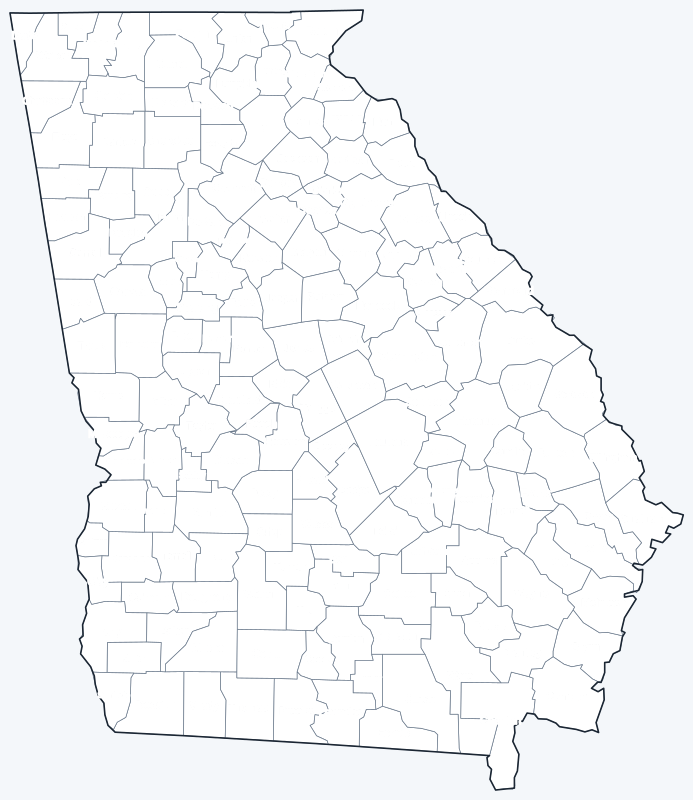
The labeled map shows every county name; the blank version has county lines only, for coloring or quizzes. Both are SVG files that print sharply at any size.
Frequently asked questions
How many counties are in Georgia?
Georgia has 159 counties, more than any state except Texas.
What is the largest county in Georgia?
Ware County, with 899.2 sq mi of land. Its county seat is Waycross.
What is the most populous county in Georgia?
Fulton County, with 1,066,710 residents in 2020, followed by Gwinnett County (957,062).
What county is Atlanta in?
Mostly Fulton County, where Atlanta is the county seat; a smaller part of the city extends into DeKalb County.
Neighboring state county maps
Alabama · Florida · North Carolina · South Carolina · Tennessee
Back to the Georgia state map or browse all 50 state maps.
Sources: U.S. Census Bureau (2020 Census, 2020 Gazetteer, boundaries); county seats from Wikipedia and Wikidata, cross-checked. Last reviewed October 2026.