Western States Map
This Western states map shows the 13 states the U.S. Census Bureau counts as the West, from the Rocky Mountains to the Pacific, plus Alaska and Hawaii. It is the largest region by far (1,873,253 sq mi) and had 78,588,572 people in 2020, 23.7% of the US.
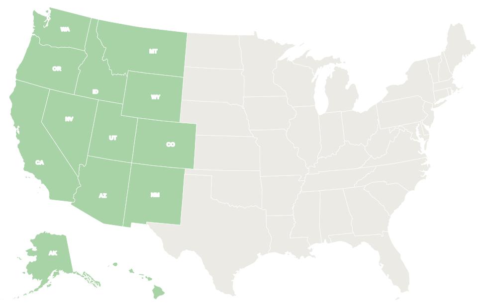
The 13 Western states are shaded green. In the interactive map, hover over a state for its name or click it for its capital and population.
States in the West
Select a column heading to sort. California has about half the region’s people; Alaska covers more than a third of its area. Wyoming is the least populous state in the country.
| State | Capital | Population (2020) | Area (sq mi) | Statehood |
|---|---|---|---|---|
| Alaska | Juneau | 733,391 | 665,384 | 1959 |
| Arizona | Phoenix | 7,151,502 | 113,990 | 1912 |
| California | Sacramento | 39,538,223 | 163,695 | 1850 |
| Colorado | Denver | 5,773,714 | 104,094 | 1876 |
| Hawaii | Honolulu | 1,455,271 | 10,932 | 1959 |
| Idaho | Boise | 1,839,106 | 83,569 | 1890 |
| Montana | Helena | 1,084,225 | 147,040 | 1889 |
| Nevada | Carson City | 3,104,614 | 110,572 | 1864 |
| New Mexico | Santa Fe | 2,117,522 | 121,590 | 1912 |
| Oregon | Salem | 4,237,256 | 98,379 | 1859 |
| Utah | Salt Lake City | 3,271,616 | 84,897 | 1896 |
| Washington | Olympia | 7,705,281 | 71,298 | 1889 |
| Wyoming | Cheyenne | 576,851 | 97,813 | 1890 |
| West total | 78,588,572 | 1,873,253 |
Pacific division
Alaska, California, Hawaii, Oregon and Washington border the Pacific Ocean and have 53,669,422 people. Alaska and Hawaii, the 49th and 50th states (both 1959), are the only states not connected to the other 48.
The division sits on the Pacific “Ring of Fire”: it includes the volcanoes of the Cascade Range, Alaska’s Aleutian Islands and Hawaii, and California’s San Andreas Fault.
Mountain division
Arizona, Colorado, Idaho, Montana, Nevada, New Mexico, Utah and Wyoming are all landlocked and have 24,919,150 people on 863,565 sq mi. The Rocky Mountains, deserts and high plateaus mean population clusters in a few metro areas such as Phoenix, Denver, Las Vegas and Salt Lake City.
Arizona, Colorado, New Mexico and Utah meet at Four Corners, the only point where four states touch. The federal government manages a large share of the land in most Mountain states.
Geography
- Mountains: the Rockies run from Montana to New Mexico and carry the Continental Divide. Farther west are the Sierra Nevada, the Cascades and the Coast Ranges. Denali in Alaska, 20,310 ft, is the highest peak in North America; Mount Whitney in California, about 14,494 ft, is the highest in the lower 48.
- Basins and deserts: the Great Basin covers most of Nevada and western Utah. The Mojave, Sonoran and Chihuahuan Deserts stretch across the Southwest, and Badwater Basin in Death Valley, 282 ft below sea level, is the lowest point in North America.
- Rivers: the Colorado River carved the Grand Canyon in Arizona. The Columbia and Snake drain the Pacific Northwest, and the Rio Grande rises in Colorado and flows through New Mexico.
- Climate: the Pacific Northwest coast is wet and mild, coastal California has dry summers and mild, rainy winters, and the Southwest is hot and arid. Alaska ranges from temperate rain forest to Arctic tundra; Hawaii is tropical.
- National parks: most US national parks are in the West, including Yellowstone, the first national park (1872), which lies mainly in Wyoming, as well as Yosemite in California and Grand Canyon in Arizona.
Major cities
The West’s largest cities by 2020 Census population. Four of the ten are in California.
| Rank | City | State | Population (2020) |
|---|---|---|---|
| 1 | Los Angeles | California | 3,898,747 |
| 2 | Phoenix | Arizona | 1,608,139 |
| 3 | San Diego | California | 1,386,932 |
| 4 | San Jose | California | 1,013,240 |
| 5 | San Francisco | California | 873,965 |
| 6 | Seattle | Washington | 737,015 |
| 7 | Denver | Colorado | 715,522 |
| 8 | Portland | Oregon | 652,503 |
| 9 | Las Vegas | Nevada | 641,903 |
| 10 | Albuquerque | New Mexico | 564,559 |
Informal sub-regions
- Pacific Northwest: Washington and Oregon, often with Idaho; the Canadian province of British Columbia is sometimes included.
- West Coast: California, Oregon and Washington.
- Southwest: Arizona and New Mexico at the core, often with southern Nevada, southern Utah, southern Colorado and West Texas.
- Mountain West: the eight Mountain division states, also called the Intermountain West or Rocky Mountain states.
- Great Basin: the desert basins of Nevada and western Utah, where rivers do not drain to the sea.
- Northern and Southern California: an informal split of the most populous state, with Los Angeles and San Diego in the south and San Francisco, San Jose and Sacramento in the north.
Printable Western states map
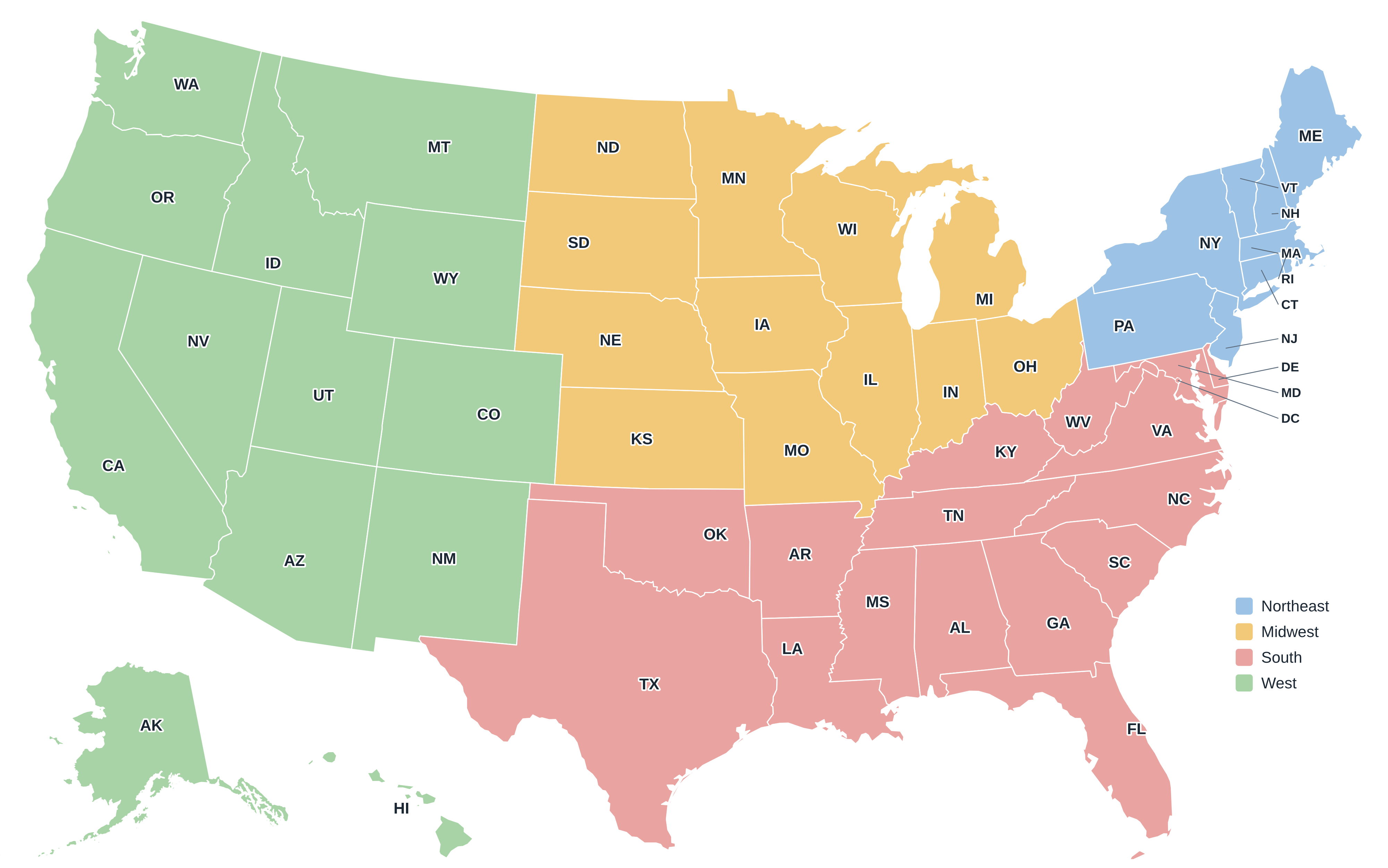
Download the West map above as an SVG, or the full US regions map as a PDF or PNG. More maps are on the printable US maps page.
Frequently asked questions
Which states are in the Western US?
Alaska, Arizona, California, Colorado, Hawaii, Idaho, Montana, Nevada, New Mexico, Oregon, Utah, Washington and Wyoming.
Is Texas a Western state?
Not in Census terms. Texas is in the South (West South Central division), though its western part is often considered the Southwest.
What is the largest Western state?
Alaska, with 665,384 sq mi, is the largest state in the country. California is the most populous, with 39,538,223 people in 2020.
Which states are in the Pacific Northwest?
Washington and Oregon, and often Idaho. It is an informal region, not a Census division.
Other US regions
Northeast · Midwest · South · Compare all four on the US regions map.
Back to the US state map or browse all 50 state maps.
Sources: U.S. Census Bureau (2020 Census, census regions and divisions, boundaries), USGS. Last reviewed October 2026.