US State Map
The United States has 50 states plus a federal district, Washington, D.C. Use the interactive map to see each state’s name, capital and population, switch layers, or click any state to open its detailed map.
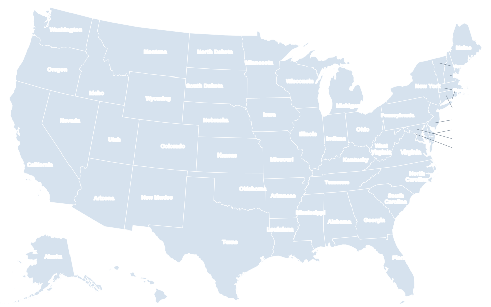
Alaska and Hawaii are shown as insets and are not to scale or in their true position. Alaska is roughly one-fifth the size of the contiguous states, not the small shape seen here.
The 50 states at a glance
Choose a US map
Labeled US map
All 50 state names, with callouts for the small Northeast states.
Blank US map
State borders only. Printable, plus a numbered worksheet with answer key.
US map with capitals
Every state capital marked, with a full list of capitals.
US map with cities
The 50 largest US cities by 2020 Census population.
State abbreviations
Two-letter USPS codes on a map, plus AP style and FIPS codes.
US regions map
The four Census regions and nine divisions, state by state.
US map quiz
Find all 50 states or match capitals, against the clock.
Printable US maps
High-resolution PDF, PNG and SVG downloads, free to print.
List of the 50 states: capitals, population and area
Click a column heading to sort. Population is from the 2020 Census; area is total area (land and water) in square miles.
| State | Abbr. | Capital | Largest city | Population (2020) | Area (sq mi) | Statehood |
|---|---|---|---|---|---|---|
| Alabama | AL | Montgomery | Huntsville | 5,024,279 | 52,420 | 1819 |
| Alaska | AK | Juneau | Anchorage | 733,391 | 665,384 | 1959 |
| Arizona | AZ | Phoenix | Phoenix | 7,151,502 | 113,990 | 1912 |
| Arkansas | AR | Little Rock | Little Rock | 3,011,524 | 53,179 | 1836 |
| California | CA | Sacramento | Los Angeles | 39,538,223 | 163,695 | 1850 |
| Colorado | CO | Denver | Denver | 5,773,714 | 104,094 | 1876 |
| Connecticut | CT | Hartford | Bridgeport | 3,605,944 | 5,543 | 1788 |
| Delaware | DE | Dover | Wilmington | 989,948 | 2,489 | 1787 |
| Florida | FL | Tallahassee | Jacksonville | 21,538,187 | 65,758 | 1845 |
| Georgia | GA | Atlanta | Atlanta | 10,711,908 | 59,425 | 1788 |
| Hawaii | HI | Honolulu | Honolulu | 1,455,271 | 10,932 | 1959 |
| Idaho | ID | Boise | Boise | 1,839,106 | 83,569 | 1890 |
| Illinois | IL | Springfield | Chicago | 12,812,508 | 57,914 | 1818 |
| Indiana | IN | Indianapolis | Indianapolis | 6,785,528 | 36,420 | 1816 |
| Iowa | IA | Des Moines | Des Moines | 3,190,369 | 56,273 | 1846 |
| Kansas | KS | Topeka | Wichita | 2,937,880 | 82,278 | 1861 |
| Kentucky | KY | Frankfort | Louisville | 4,505,836 | 40,408 | 1792 |
| Louisiana | LA | Baton Rouge | New Orleans | 4,657,757 | 52,378 | 1812 |
| Maine | ME | Augusta | Portland | 1,362,359 | 35,380 | 1820 |
| Maryland | MD | Annapolis | Baltimore | 6,177,224 | 12,406 | 1788 |
| Massachusetts | MA | Boston | Boston | 7,029,917 | 10,554 | 1788 |
| Michigan | MI | Lansing | Detroit | 10,077,331 | 96,714 | 1837 |
| Minnesota | MN | Saint Paul | Minneapolis | 5,706,494 | 86,936 | 1858 |
| Mississippi | MS | Jackson | Jackson | 2,961,279 | 48,432 | 1817 |
| Missouri | MO | Jefferson City | Kansas City | 6,154,913 | 69,707 | 1821 |
| Montana | MT | Helena | Billings | 1,084,225 | 147,040 | 1889 |
| Nebraska | NE | Lincoln | Omaha | 1,961,504 | 77,348 | 1867 |
| Nevada | NV | Carson City | Las Vegas | 3,104,614 | 110,572 | 1864 |
| New Hampshire | NH | Concord | Manchester | 1,377,529 | 9,349 | 1788 |
| New Jersey | NJ | Trenton | Newark | 9,288,994 | 8,723 | 1787 |
| New Mexico | NM | Santa Fe | Albuquerque | 2,117,522 | 121,590 | 1912 |
| New York | NY | Albany | New York City | 20,201,249 | 54,555 | 1788 |
| North Carolina | NC | Raleigh | Charlotte | 10,439,388 | 53,819 | 1789 |
| North Dakota | ND | Bismarck | Fargo | 779,094 | 70,698 | 1889 |
| Ohio | OH | Columbus | Columbus | 11,799,448 | 44,826 | 1803 |
| Oklahoma | OK | Oklahoma City | Oklahoma City | 3,959,353 | 69,899 | 1907 |
| Oregon | OR | Salem | Portland | 4,237,256 | 98,379 | 1859 |
| Pennsylvania | PA | Harrisburg | Philadelphia | 13,002,700 | 46,054 | 1787 |
| Rhode Island | RI | Providence | Providence | 1,097,379 | 1,545 | 1790 |
| South Carolina | SC | Columbia | Charleston | 5,118,425 | 32,020 | 1788 |
| South Dakota | SD | Pierre | Sioux Falls | 886,667 | 77,116 | 1889 |
| Tennessee | TN | Nashville | Nashville | 6,910,840 | 42,144 | 1796 |
| Texas | TX | Austin | Houston | 29,145,505 | 268,596 | 1845 |
| Utah | UT | Salt Lake City | Salt Lake City | 3,271,616 | 84,897 | 1896 |
| Vermont | VT | Montpelier | Burlington | 643,077 | 9,616 | 1791 |
| Virginia | VA | Richmond | Virginia Beach | 8,631,393 | 42,775 | 1788 |
| Washington | WA | Olympia | Seattle | 7,705,281 | 71,298 | 1889 |
| West Virginia | WV | Charleston | Charleston | 1,793,716 | 24,230 | 1863 |
| Wisconsin | WI | Madison | Milwaukee | 5,893,718 | 65,496 | 1848 |
| Wyoming | WY | Cheyenne | Cheyenne | 576,851 | 97,813 | 1890 |
States by region
The U.S. Census Bureau groups the states into four regions. See the US regions map for the nine divisions within them.
Northeast (9 states)
Connecticut, Maine, Massachusetts, New Hampshire, New Jersey, New York, Pennsylvania, Rhode Island, Vermont
Midwest (12 states)
Illinois, Indiana, Iowa, Kansas, Michigan, Minnesota, Missouri, Nebraska, North Dakota, Ohio, South Dakota, Wisconsin
South (16 states)
Alabama, Arkansas, Delaware, Florida, Georgia, Kentucky, Louisiana, Maryland, Mississippi, North Carolina, Oklahoma, South Carolina, Tennessee, Texas, Virginia, West Virginia
West (13 states)
Alaska, Arizona, California, Colorado, Hawaii, Idaho, Montana, Nevada, New Mexico, Oregon, Utah, Washington, Wyoming
How to read a US state map
Most maps of the United States, including this one, use an Albers equal-area projection. It keeps the relative size of the contiguous states accurate, which is why the northern border looks curved rather than straight. Alaska and Hawaii are moved into insets at the lower left so the map fits a single page; Alaska is also shrunk, so it looks far smaller than it really is. At 665,384 square miles, Alaska is larger than Texas, California and Montana combined.
The 48 contiguous states (often called the “lower 48”) share borders with each other. Alaska borders Canada only, and Hawaii is an island chain in the central Pacific about 2,400 miles from California. Washington, D.C., sits between Maryland and Virginia and belongs to no state.
Frequently asked questions
How many states are in the United States?
There are 50 states. The country also includes Washington, D.C. (a federal district) and five inhabited territories: Puerto Rico, Guam, the U.S. Virgin Islands, the Northern Mariana Islands and American Samoa.
Which states border the most other states?
Tennessee and Missouri each border eight states. Tennessee touches Kentucky, Virginia, North Carolina, Georgia, Alabama, Mississippi, Arkansas and Missouri.
What are the Four Corners states?
Arizona, Colorado, New Mexico and Utah meet at a single point, the only place in the US where four states touch.
Which state is the largest and which is the smallest?
By total area, Alaska (665,384 sq mi) is the largest and Rhode Island (1,545 sq mi) is the smallest. Texas is the largest of the contiguous states.
What are the two newest states?
Alaska (January 3, 1959) and Hawaii (August 21, 1959). Before them, the last state admitted was Arizona in 1912.
Is this US map free to use?
Yes. You can print the maps and use them for personal, classroom and non-commercial projects. High-resolution files are on the printable US maps page.
Sources: U.S. Census Bureau (2020 Census, cartographic boundary files). Last reviewed October 2026.