Iowa County Map
Iowa has 99 counties. Polk County is the most populous, with 492,401 residents in 2020, and Kossuth County is the largest by land area at 972.7 sq mi. The capital, Des Moines, is the seat of Polk County.
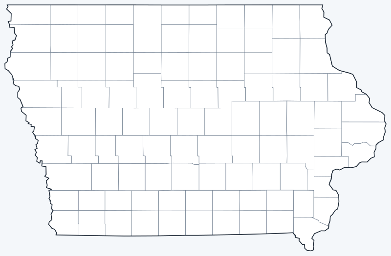
County lines are switched on when the interactive map loads, over an OpenStreetMap base map with major cities (capital in red). Hover over a county to see its name, or untick Show counties to hide the lines.
List of Iowa counties
| County | County seat | Population (2020) | Land area (sq mi) |
|---|---|---|---|
| Adair County | Greenfield | 7,496 | 569.3 |
| Adams County | Corning | 3,704 | 423.4 |
| Allamakee County | Waukon | 14,061 | 639.0 |
| Appanoose County | Centerville | 12,317 | 497.3 |
| Audubon County | Audubon | 5,674 | 443.0 |
| Benton County | Vinton | 25,575 | 716.1 |
| Black Hawk County | Waterloo | 131,144 | 565.8 |
| Boone County | Boone | 26,715 | 570.5 |
| Bremer County | Waverly | 24,988 | 435.5 |
| Buchanan County | Independence | 20,565 | 571.1 |
| Buena Vista County | Storm Lake | 20,823 | 574.9 |
| Butler County | Allison | 14,334 | 580.1 |
| Calhoun County | Rockwell City | 9,927 | 569.8 |
| Carroll County | Carroll | 20,760 | 569.5 |
| Cass County | Atlantic | 13,127 | 564.3 |
| Cedar County | Tipton | 18,505 | 579.5 |
| Cerro Gordo County | Mason City | 43,127 | 568.3 |
| Cherokee County | Cherokee | 11,658 | 576.9 |
| Chickasaw County | New Hampton | 12,012 | 504.3 |
| Clarke County | Osceola | 9,748 | 431.1 |
| Clay County | Spencer | 16,384 | 567.2 |
| Clayton County | Elkader | 17,043 | 778.5 |
| Clinton County | Clinton | 46,460 | 695.0 |
| Crawford County | Denison | 16,525 | 714.2 |
| Dallas County | Adel | 99,678 | 588.3 |
| Davis County | Bloomfield | 9,110 | 502.2 |
| Decatur County | Leon | 7,645 | 531.9 |
| Delaware County | Manchester | 17,488 | 577.7 |
| Des Moines County | Burlington | 38,910 | 416.1 |
| Dickinson County | Spirit Lake | 17,703 | 380.5 |
| Dubuque County | Dubuque | 99,266 | 608.3 |
| Emmet County | Estherville | 9,388 | 395.9 |
| Fayette County | West Union | 19,509 | 730.8 |
| Floyd County | Charles City | 15,627 | 500.6 |
| Franklin County | Hampton | 10,019 | 582.0 |
| Fremont County | Sidney | 6,605 | 511.2 |
| Greene County | Jefferson | 8,771 | 569.6 |
| Grundy County | Grundy Center | 12,329 | 501.9 |
| Guthrie County | Guthrie Center | 10,623 | 590.6 |
| Hamilton County | Webster City | 15,039 | 576.7 |
| Hancock County | Garner | 10,795 | 571.0 |
| Hardin County | Eldora | 16,878 | 569.3 |
| Harrison County | Logan | 14,582 | 696.9 |
| Henry County | Mount Pleasant | 20,482 | 434.3 |
| Howard County | Cresco | 9,469 | 473.2 |
| Humboldt County | Dakota City | 9,597 | 434.4 |
| Ida County | Ida Grove | 7,005 | 431.5 |
| Iowa County | Marengo | 16,662 | 586.5 |
| Jackson County | Maquoketa | 19,485 | 636.0 |
| Jasper County | Newton | 37,813 | 730.4 |
| Jefferson County | Fairfield | 15,663 | 435.5 |
| Johnson County | Iowa City | 152,854 | 613.0 |
| Jones County | Anamosa | 20,646 | 575.6 |
| Keokuk County | Sigourney | 10,033 | 579.2 |
| Kossuth County | Algona | 14,828 | 972.7 |
| Lee County | Fort Madison and Keokuk | 33,555 | 517.6 |
| Linn County | Cedar Rapids | 230,299 | 717.1 |
| Louisa County | Wapello | 10,837 | 401.8 |
| Lucas County | Chariton | 8,634 | 430.7 |
| Lyon County | Rock Rapids | 11,934 | 587.6 |
| Madison County | Winterset | 16,548 | 561.0 |
| Mahaska County | Oskaloosa | 22,190 | 570.9 |
| Marion County | Knoxville | 33,414 | 554.5 |
| Marshall County | Marshalltown | 40,105 | 572.5 |
| Mills County | Glenwood | 14,484 | 437.4 |
| Mitchell County | Osage | 10,565 | 469.3 |
| Monona County | Onawa | 8,751 | 694.1 |
| Monroe County | Albia | 7,577 | 433.7 |
| Montgomery County | Red Oak | 10,330 | 424.1 |
| Muscatine County | Muscatine | 43,235 | 437.4 |
| O'Brien County | Primghar | 14,182 | 573.0 |
| Osceola County | Sibley | 6,192 | 398.7 |
| Page County | Clarinda | 15,211 | 534.9 |
| Palo Alto County | Emmetsburg | 8,996 | 563.9 |
| Plymouth County | Le Mars | 25,698 | 862.8 |
| Pocahontas County | Pocahontas | 7,078 | 577.2 |
| Polk County | Des Moines | 492,401 | 572.2 |
| Pottawattamie County | Council Bluffs | 93,667 | 951.3 |
| Poweshiek County | Montezuma | 18,662 | 584.9 |
| Ringgold County | Mount Ayr | 4,663 | 535.5 |
| Sac County | Sac City | 9,814 | 575.0 |
| Scott County | Davenport | 174,669 | 458.1 |
| Shelby County | Harlan | 11,746 | 590.8 |
| Sioux County | Orange City | 35,872 | 767.9 |
| Story County | Nevada | 98,537 | 572.5 |
| Tama County | Toledo | 17,135 | 721.0 |
| Taylor County | Bedford | 5,896 | 531.9 |
| Union County | Creston | 12,138 | 423.6 |
| Van Buren County | Keosauqua | 7,203 | 484.8 |
| Wapello County | Ottumwa | 35,437 | 431.8 |
| Warren County | Indianola | 52,403 | 569.8 |
| Washington County | Washington | 22,565 | 568.8 |
| Wayne County | Corydon | 6,497 | 525.5 |
| Webster County | Fort Dodge | 36,999 | 715.7 |
| Winnebago County | Forest City | 10,679 | 400.5 |
| Winneshiek County | Decorah | 20,070 | 689.8 |
| Woodbury County | Sioux City | 105,941 | 872.9 |
| Worth County | Northwood | 7,443 | 400.1 |
| Wright County | Clarion | 12,943 | 580.4 |
Click a column heading to sort. Land area excludes water. Lee County has two county seats.
Most populous counties
Iowa had 3,190,369 residents in the 2020 Census. The five most populous counties held 37.0 percent of them:
- Polk County (seat Des Moines): 492,401, or 15.4 percent of the state
- Linn County (seat Cedar Rapids): 230,299, or 7.2 percent of the state
- Scott County (seat Davenport): 174,669, or 5.5 percent of the state
- Johnson County (seat Iowa City): 152,854, or 4.8 percent of the state
- Black Hawk County (seat Waterloo): 131,144, or 4.1 percent of the state
The least populous is Adams County, with 3,704 residents. The median Iowa county had 15,211 people in 2020.
Largest and smallest counties
By land area, the largest Iowa counties are Kossuth County (972.7 sq mi), Pottawattamie County (951.3 sq mi) and Woodbury County (872.9 sq mi). The smallest are Dickinson County (380.5 sq mi), Emmet County (395.9 sq mi) and Osceola County (398.7 sq mi).
The average Iowa county covers 564.2 sq mi of land. Kossuth County is 2.6 times the land area of Dickinson County.
How counties work in Iowa
Most of Iowa’s 99 counties are near-square blocks laid out on the federal public land survey grid, which gives the county map its checkerboard pattern. Each county is governed by an elected board of supervisors.
Lee County, in the far southeast corner on the Mississippi River, is the only Iowa county with two county seats: Fort Madison and Keokuk, each with its own courthouse.
Polk County holds Des Moines, the capital and largest city, along with suburbs such as Ankeny.
Printable Iowa county maps
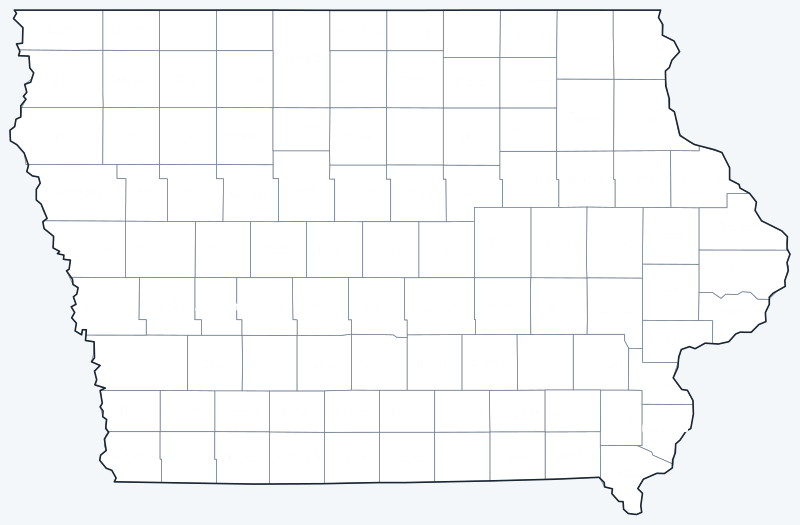
Download the labeled map with every county name, or the blank county map for quizzes and coloring; both are SVG files that print sharply at any size and are free for personal and classroom use.
Frequently asked questions
How many counties are in Iowa?
Iowa has 99 counties. Polk County has the most people and Adams County the fewest.
What is the largest county in Iowa?
Kossuth County, with 972.7 sq mi of land. Its seat is Algona.
What is the most populous county in Iowa?
Polk County, with 492,401 residents in the 2020 Census, 15.4 percent of the state total.
Which Iowa county has two county seats?
Lee County, with courthouses in Fort Madison and Keokuk.
More Iowa and county maps
See the Iowa state map for cities, geography and highways.
County maps of neighboring states: Illinois · Minnesota · Missouri · Nebraska · South Dakota · Wisconsin
Browse all 50 state maps.
Sources: U.S. Census Bureau (2020 Census, 2020 Gazetteer, boundaries); county seats from Wikipedia county lists cross-checked with Wikidata. Last reviewed October 2026.